


Naviator

Description of Naviator
Naviator is a full-featured moving map GPS application designed for pilots, providing crucial navigation assistance during flights. It is available for the Android platform and offers a free 30-day trial, allowing users to explore its extensive features before committing to a subscription. Naviator simplifies flight planning and navigation, making it an essential tool for both recreational and professional aviators.
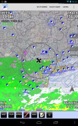
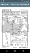
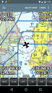
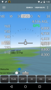
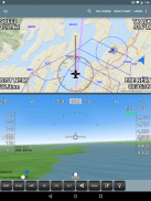
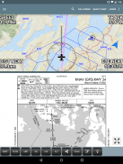
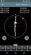
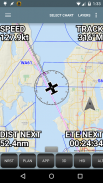
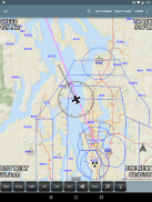
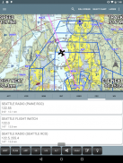
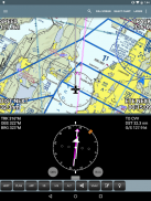
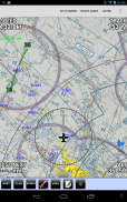
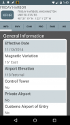
The application includes a GPS moving map that displays vital information such as airspace classifications, airport locations, radio navigation aids, airway intersections, and Temporary Flight Restrictions (TFRs). This wealth of navigational data is pre-downloaded to the device, ensuring that users do not require an internet connection while flying. This capability enhances reliability, particularly in remote areas where connectivity can be limited or nonexistent.
For flight planning, Naviator provides an intuitive "rubber band" feature that allows users to create and adjust flight paths easily. This functionality streamlines the planning process, enabling pilots to visualize their routes effectively. Additionally, the app integrates seamlessly with X-Plane, a popular flight simulation software, through the "X-Plane to GPS" application, enhancing the user experience for both training and actual flights.
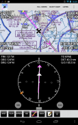
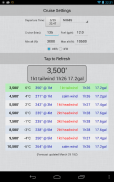
Weather information is readily accessible within the app, allowing pilots to obtain real-time weather briefings and file flight plans directly from the interface. This integration supports informed decision-making, contributing to safer flight operations. The vertical navigation (VNAV) calculator is another tool that assists pilots in managing altitudes during their flights, further enhancing navigational precision.
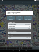
Naviator also offers comprehensive Canadian data, including information on airspace, airports, navigation aids, terrain, and weather. This feature is particularly beneficial for pilots operating in or traveling to Canada, as it ensures they have access to relevant and up-to-date information for their flights. The application supports NMEA output, enabling it to interface with various aircraft autopilot systems, which can enhance automated flight operations.
Pilots can import custom charts and maps into the app using the "Bring Your Own Charts" feature. This flexibility allows users to tailor their navigational resources to meet specific needs, making it a versatile tool for pilots with diverse requirements. The app also supports ADS-B receivers, including popular models such as the iLevil AW/SW and Dual XGPS 170, facilitating real-time traffic display and improving situational awareness during flights.
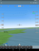
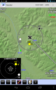
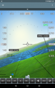
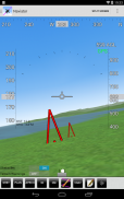
Naviator incorporates 3D synthetic vision, providing a visual representation of terrain, obstacles, towers, and runways. This feature aids in hazard recognition and enhances pilot awareness of their surroundings. The global terrain database included in the app offers terrain warnings, ensuring that pilots are alerted to potential risks during their flights.
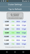
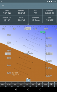
The Global Forecast Engine is another critical feature, delivering winds aloft information up to an altitude of 54,000 feet. This data is essential for flight planning as it helps pilots assess wind conditions and make informed route adjustments accordingly. The app also allows users to record their GPS tracks, which can be uploaded to their personalized Naviator Hangar, providing an opportunity to review and share flight experiences.
For those who use other flight planning systems, Naviator facilitates the import of routes using the GPX format. This interoperability supports a seamless transition between different tools, allowing users to maintain their preferred flight planning methods without disruption. Additionally, the app integrates with Microsoft Flight Simulator and Prepar3D, making it suitable for both virtual training and real-world applications.
Naviator offers flexible subscription options after the initial 30-day trial. Users can choose between a 30-day chart subscription for $4.99 or a one-year chart subscription for $34.99. For pilots who do not operate within the United States, a one-time charge of $14.99 allows them to unlock all features of the app, with some exceptions related to specific FAA charts and TFR updates.
The app's user-friendly interface, combined with its extensive functionality, makes it a valuable resource for pilots seeking reliable and efficient navigation solutions. With the ability to download and utilize the app's features effectively, users can enhance their flying experience significantly.
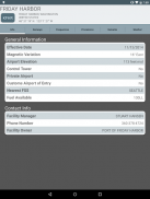
For more information and to access the support forum, users can visit the Naviator website and the dedicated support forum.

Naviator - APK Information
APK Version: 4.2.2Package: com.onetwentythree.skynavLatest Version of Naviator
Other versions


Apps in the same category


